Mulholland Drive and the Canyons - A Local's Guide to Riding LA Without Touching the Freeway
Apr 26, 2026
Tags:routes
There are over 50 miles of canyon roads running through the Santa Monica Mountains above Los Angeles, and you can ride every one of them without ever getting on a freeway. The Mulholland Drive motorcycle route starts in Hollywood, turns into Mulholland Highway past Topanga Canyon, and winds through some of the best riding in Southern California: The Snake, the Rock Store, Malibu Canyon, Decker Canyon, and a dozen turns that'll make you forget PCH exists. The Snake was closed for nearly seven years after the 2018 Woolsey Fire, but it reopened in December 2025, so the full route is back for the first time since 2019.
Rent a motorcycle in Los Angeles through Riders Share and you can be on Mulholland in under 20 minutes from most parts of the city.

The Mulholland Drive Motorcycle Route
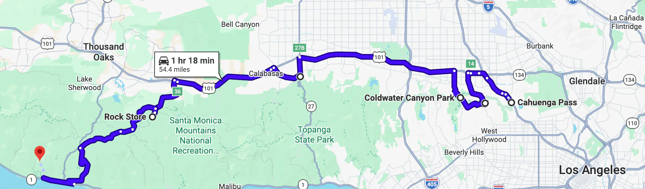
Mulholland runs about 50 miles from the 101 in Hollywood to PCH at Leo Carrillo State Park. The name changes from Mulholland Drive to Mulholland Highway at Topanga Canyon Boulevard, and that's where the riding changes too.
Mulholland Drive (Cahuenga Pass to Woodland Hills)
The first 21 miles start at Cahuenga Pass where Mulholland meets the 101 in Hollywood. You'll head west through the Hollywood Hills with the San Fernando Valley on one side and the LA skyline on the other. Any bike at any experience level will be comfortable here.
Key stops
- Laurel Canyon (about 2 miles west of Cahuenga Pass)
- Coldwater Canyon (about 5 miles west, park with valley views)
- Benedict Canyon (about 8 miles west)
- Stone Canyon Overlook (about 12 miles west, views of the reservoir and the coast on clear days)
Mulholland Highway Through the Santa Monica Mountains
West of Topanga Canyon, the road tightens into 30 miles of mountain riding to Leo Carrillo State Park on PCH. One section has tree canopy closing in overhead, the next has exposed rock walls right along the edge of the pavement. The road is constantly climbing and dropping between about 1,000 and 2,200 feet, and the turns get tighter the further west you go. Advisory speed signs drop to 15-25 mph on some of them.
Key stops
- The Snake (2.4 miles between Kanan Road and Sierra Creek Road)
- The Rock Store (30354 Mulholland Highway, Cornell)
- Malibu Canyon Road connection (near Malibu Creek State Park, heads south to PCH)
- Decker Canyon Road connection (further west, climbs between Mulholland and PCH)
TIP: There are no gas stations along Mulholland Highway between Calabasas and PCH. Fill up before you leave, because the closest fuel to the Rock Store is back on the 101 or down a canyon road to the coast.
Malibu Canyon Road Motorcycle Ride
Two of the key stops on Mulholland Highway, Malibu Canyon and Decker Canyon, are canyon roads that drop south from Mulholland down to PCH. Malibu Canyon is the more relaxed of the two. It runs about 7 miles from Mulholland Highway near Malibu Creek State Park south to the coast, and it's the widest canyon road in the Santa Monica Mountains.
Who it's good for
- Any bike, any skill level
- Riders who want canyon riding without steep grades
Decker Canyon Motorcycle Ride
Decker Canyon is the other route between Mulholland and PCH, and it's a completely different ride from Malibu Canyon. It climbs about 4 miles from PCH north of Malibu up to Mulholland Highway, with grades above 10% in places and a road that gains elevation quickly. The ocean views get better the higher you go, and by the time you reach Mulholland Highway at the top, you can see down the coast.
Who it's good for
- Lighter bikes have a clear advantage on the steep sections
- If you're on a heavier bike (700+ pounds), Malibu Canyon is the easier route between Mulholland and PCH
The LA Canyon Roads Loop
If you're riding both Malibu Canyon and Decker Canyon, you can tie them together with Mulholland Highway and a short stretch of PCH to make a 37-mile loop that brings you back to where you started at the Rock Store.
The route
- Head west on Mulholland Highway past the Rock Store and The Snake
- Drop down Decker Canyon to PCH
- Ride the coast for a few miles
- Climb back up Malibu Canyon Road to rejoin Mulholland
- Back to the Rock Store
Distance and time
- About 37 miles for the full loop
- Plan for 1.5 to 2 hours depending on stops
- Each section of the loop rides completely differently: mountain, steep canyon, coast, then a wider canyon climb back up
The Snake Motorcycle Road on Mulholland Highway
If there's one section of Mulholland that riders have heard of before they even plan the trip, it's The Snake. It's the road you've seen in all those YouTube videos filmed from the pullouts above, and now that it's back open after seven years, it's going to be the busiest section of the route.
What Is The Snake Motorcycle Road in Los Angeles?
The Snake is a 2.4-mile section of Mulholland Highway between Kanan Road and Sierra Creek Road. The turns come one after another, they reverse direction on you quickly, and the road loses elevation the whole way through with not a lot of room on either side. It rides exactly how it looks in those videos, and it's probably the most well-known motorcycle road in all of Southern California.
The Woolsey Fire and Seven-Year Closure
The 2018 Woolsey Fire hit this section hard. It destroyed guardrails, burned through the pavement, and took out a bridge. The road closed to vehicles in early 2019, and it stayed closed for nearly seven years while LA County rebuilt it.
What's Changed Since The Snake Reopened
LA County didn't just patch the damage and reopen. They used those seven years to add a full set of safety upgrades under the county's Vision Zero initiative:
- Centerline rumble strips
- Reflective pavement markers and updated striping
- Warning signs and bollards at the sharpest turns
- Increased CHP patrols
- Enforcement against illegal parking
The road reopened on December 2, 2025, and a crash happened the very next day when a driver lost control on one of the turns. If you take anything from that, ride this section at whatever pace you're comfortable with and don't worry about keeping up with anyone else.
Best Time to Ride The Snake
Weekends bring crowds to the pullouts and heavy CHP enforcement. If you can go on a Tuesday or Wednesday morning around 9 or 10 a.m., you'll have open sight lines and room to ride without anyone on you the whole time.
The Rock Store Motorcycle Meetup on Mulholland Highway
The Rock Store is about a mile past The Snake heading east on Mulholland Highway, and you'll know it when you see bikes lined up along the road and an old stone building set back from the pavement in the community of Cornell. It's been a motorcycle meetup spot for over 60 years, and stopping here is as much a part of riding Mulholland as any section of road.
Ed and Veronica "Vern" Savko bought the building in 1961 and turned it into a grocery store, and as Mulholland connected to more canyon roads over the decades, riders started making it a regular stop. By the 1980s it had become the main gathering spot for the Southern California riding community.
Where is the Rock Store Motorcycle Meetup Spot?
- The Rock Store Location: 30354 Mulholland Highway in Cornell, California
Rock Store Hours
- Friday: 9 a.m. to 5 p.m.
- Saturday and Sunday: 7 a.m. to 5 p.m.
- Monday through Thursday: Closed
What Type of Motorcycle is Best for the LA Canyons?
Now that you know the roads, here's what to ride on them. A middleweight naked bike or sport bike in the 650-900cc range gives you the best balance for riding LA's canyon roads. Bikes like the Yamaha MT-07, Kawasaki Z650, and Ducati Monster are light enough for the tighter canyon roads on the western half of the route but still comfortable for the 21-mile Mulholland Drive section through the Hollywood Hills.
If You're Riding a Cruiser or Touring Bike
You don't have to skip the Los Angeles canyon motorcycle route on a heavier bike, but plan around it. Mulholland Drive and Malibu Canyon Road are comfortable on anything kind of bike. For The Snake and Decker Canyon, just know that the riding is more demanding and a heavier machine will take more effort to manage through those sections.
Browse Los Angeles Motorcycle Rentals on Riders Share
Riders Share has 200+ motorcycle rentals in Los Angeles, including Yamaha, Kawasaki, Ducati, Harley-Davidson, and BMW. You can add a helmet starting at $10, gloves from $5, and other gear when you book, so all that’s left is choosing your bike and heading into the canyons.
Tips for Riding Mulholland and the LA Canyons
Before you ride any of these roads, there are things that locals know from experience that most Mulholland guides leave out:
- Check for gravel in shaded sections. Sand and debris build up where the sun doesn't reach, especially on the north-facing turns between the Rock Store and Leo Carrillo.
- Bring layers. The valley floor at Cahuenga Pass can be 75 degrees while a shaded canyon section on Mulholland Highway sits in the mid-50s at 8 a.m.
- Wait a day after rain. Hillside debris washes onto the road during storms and doesn't get cleared quickly on the canyon roads. One dry day minimum before heading out.
- Don't trust the center line on Mulholland Highway. Cars and other bikes cut corners on the tighter turns, especially on weekends. Stay in your lane and expect oncoming traffic to drift.
- Parking at the Rock Store fills up fast on weekends. If you're riding on a Saturday or Sunday morning, get there early or be ready to park along the road.
Mulholland Drive Motorcycle Ride (FAQ)
If you’re still figuring out routes, timing, or what to ride, here are a few quick answers to the questions most riders have after going through it all.
What are the best canyon roads in Los Angeles for motorcycles?
The best canyon roads in LA all connect to or branch off Mulholland Highway in the Santa Monica Mountains:
- Mulholland Highway: The most well-known canyon route in LA
- Malibu Canyon Road: Wider, more forgiving, good for all skill levels
- Decker Canyon Road: Steep with tight turns, better for lighter bikes
- Encinal Canyon Road: Steady climb with ocean views
- Latigo Canyon Road: Tight turns through the hills
Is Mulholland Drive good for motorcycles?
Mulholland is one of the most popular motorcycle rides in the LA area, and it's rideable year-round. The route covers 50+ miles across the Santa Monica Mountains with no freeway riding at any point.
How far is Mulholland Drive from downtown Los Angeles?
Cahuenga Pass is about 10 miles north of downtown LA, so from most parts of the city you can be on Mulholland in 15 to 20 minutes.
How long is the Mulholland Drive motorcycle ride?
The full route from Cahuenga Pass to Leo Carrillo State Park is about 50 miles. Plan for 2-3 hours with stops on the main route, or half a day if you're adding Decker Canyon, Malibu Canyon, and time at the Rock Store.
Is Mulholland Highway Open for Motorcycles in 2026?
As of early 2026, the full Mulholland route is open to motorcycles, including The Snake section that was closed for nearly seven years. The Snake reopened on December 2, 2025, after extensive repairs and safety upgrades following the 2018 Woolsey Fire.
Current Road Status (Early 2026)
- Mulholland Drive (east): Open
- Mulholland Highway (west): Open, including The Snake
- Decker Canyon Road: Open
- Malibu Canyon Road: Open
Mudslides, fire damage, or construction, can close Milholland on short notice, so always check LA County's road closure list the morning of your ride.
Summary
Mulholland gives you 50 miles of mountain riding above Los Angeles, from the Hollywood Hills all the way to the Pacific at Leo Carrillo State Park, and the canyon roads that branch off it add another 37 miles if you ride the full Decker-Malibu Canyon loop. The Snake is back open, the Rock Store is still serving coffee on weekends, and the whole route plays out without a single freeway on-ramp. If you've been looking for an LA ride that's more about the riding than the scenery, this is the one.
More Riding in Southern California
Related Articles
Mon - Fri: 8-8 CT
Weekends: 9-8 CT
